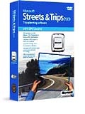
 The Bullet Points: Microsoft Streets and Trips 2009 is a mapping program that allows you to view street maps and plan routes within the continental U.S. And Canada. The GPS Locator version adds a Pharos GPS-500 unit that tells Streets and Trips where you are. Streets and Trips comes in two versions: with and without the GPS unit. The GPS Locator version is reviewed here.
What’s In The Box: Streets & Trips 2009 software DVD, Pharos GPS-500 unit with USB adapter, 16 page instruction manual.
System Requirements: Windows compatible computer with 300 MHz or better CPU (more is better), USB port, 128 MB RAM for Windows XP (more is better), 1 GB RAM for Windows Vista (more is better), 1.8 GB free hard drive space.
The Competition: DeLorme Earthmate GPS LT-400 2009, iGuidance 2009 + GPS.
The Review: Microsoft Streets & Trips is a mapping program that generates road maps and driving instructions on a Windows-based PC. The program is available with an optional GPS unit that turns it into a real-time driving guide. The version reviewed here is Streets & Trips with GPS.

What’s new?
-
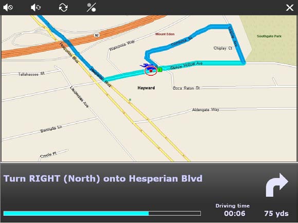
New Navigation View with a perspective looking forward from above, similar to dedicated driving GPSs. (This reminds me of flying traffic watch.)
-
Spoken street names, notably missing from previous versions, make the program more like dedicated driving GPSs.
-
Automatic rerouting if you drive off the planned route. In previous versions you had to manually tell the program to reroute.
-
Send to Mobile: send information via text messaging to your phone. Why bother with a computer program for maps when mapping Web sites are so commonly available? Well, for one thing, on the road wireless Internet access isn’t exactly universal, and Internet access by mobile phone will cost you the price of a laptop computer over a year’s time. It’s always possible to print maps from your desktop PC and take them with you, but that’s no help when your plans change on the road (mine often do). If you’ve ever tried to get comprehensible driving instructions from someone over the phone, you can begin to appreciate why a mapping program on a laptop can save you time and grief.
Installation is straightforward Windows stuff. They removed the option to run from DVD, so the whole 1.8 GB goes on your hard drive. (Not much of a penalty though, as all recent laptops have large hard drives.) The only caveat is the warning not to plug the GPS into the computer before installing the software.
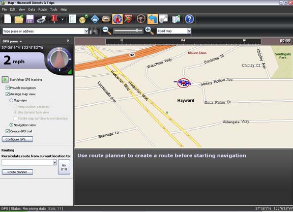
After starting the program, you notice that it’s the same, only different. The program has received a facelift, but the screen layout and toolbars remain the same, as do the task panes. If you have used previous versions, you will hit the ground running. If you are new to the program, the interface is simple enough that the learning curve is minimal. You may spend a few minutes looking for a function that you expect will be there, but you won’t have to hunt very far. The GPS drivers are included in the program, so once you install the program, you are ready to plug in the GPS and go.
The GPS unit is a Pharos iGPS-500 modular unit with a USB adapter and USB cable. The advantage of it coming in three pieces is that you can plug the GPS unit into your laptop without the messiness of a cable, but if reception is limited, you can still use the cable and place the GPS unit in a clear reception area. Better use of this modularity is to get a bluetooth adapter for the iGPS-500 (about $49) and avoid cables altogether.
The iGPS-500 is NMEA and SiRF starIII compatible, so it will work with many other modern consumer devices, like smartphones. The NMEA part (National Marine Electronics Association) means compatible with a lot of other hardware devices. The SiRF starIII part means that it has better reception in difficult environments mostly because it is capable of receiving 20 satellites simultaneously and using the best signals from five of them. The iGPS-500 also distinguishes itself by using only 50 milliamps of power, so if your laptop is one of those that current limits the USB ports when running on battery power, the iGPS-500 will still function.

The mapping and routing features of Streets & Trips are similar to other mapping programs, so it might be more useful to talk about the pointy parts:
Nits:
-
The spoken instructions only pop up at 0.3 miles from the approaching turning point. While this is appropriate at in-town speeds, it is too late at freeway speeds when you have four lanes to cross to make the exit.
-
The setup time for the whole thing (computer on, program started, satellite acquisition, entering the destination address, etc. require a fair amount of preparation before you get in the car. It is considerably clumsier than a dedicated driving GPS.
-
If you plug the GPS into a different USB port than you used last time, you have to run the Configure GPS wizard again for the program to find it. Add this to the delay in getting started.
Picks:
-
The GPS satellite acquisition time is notably shorter than previous devices that I’ve used. The sensitivity and resistance to dropout seems better also.
-
The spoken driving instructions include both direction of turn and compass direction. The Navigation View includes a compass view at the top of the map. Makes more sense for pilot types like me.
-
On-screen driving instructions are in large, clear type, making them easy to read at a glance while driving. The new dark program interface is also easier to read.
Let me be real clear about something. This, like other driving GPSs, is not something that you can turn on after starting the engine and program while driving down the road. It is useful if you do some data entry before getting in the car. It is useful if your plans change en route, but you better stop the car to change the destination.
En route, the verbal driving instructions are spoken clearly in a female robot voice. They include turning instructions, street names, freeway names and numbers, and a warning of the next decision point after executing the turn. The map automatically zooms in when you are approaching a decision point, presenting a more detailed view of the upcoming route.
The program is much closer to a dedicated driving GPS than previous versions. The spoken instructions, a literal read of the onscreen text instructions, are generally comprehensible, but can occasionally be confusing. Then the large font onscreen instructions become useful: they can be read at a glance. The whole package provides timely and comprehensible information most of the time, but there are times when the verbal instructions are not clear. Like any other driving GPS, don’t take it literally all the time.
In summary, Streets & Trips is a generally useful and portable mapping program. The GPS feature I put in the occasionally useful but mostly entertaining category. The refinements on the interface make this a worthy upgrade, and the new perspective view puts it more in line with the competition, notably iGuidance, who I think still has the edge with its map display. Streets & Trips still hold the edge on price and is otherwise as functional as the competition. If you need a fully capable mapping program, or just want it for the occasional driving instructions, get it. Highly recommended.
Product Information
Microsoft Streets & Trips 2009 With GPS
Web price $69
Microsoft Corp.
1 Microsoft Way
Redmond, WA
www.microsoft.com/streets


